Version 1.2 Last Updated 25 Oct 2019
If you're anything like me, you will have built up a large collection of digital photos from your phone or camera but may have forgotten where many of those photos were taken
This example app is designed to manage that situation. It was prompted by a request from AWF member MickJav in this thread at Access World Forums
It was adapted from my earlier example app Get Current Geolocation
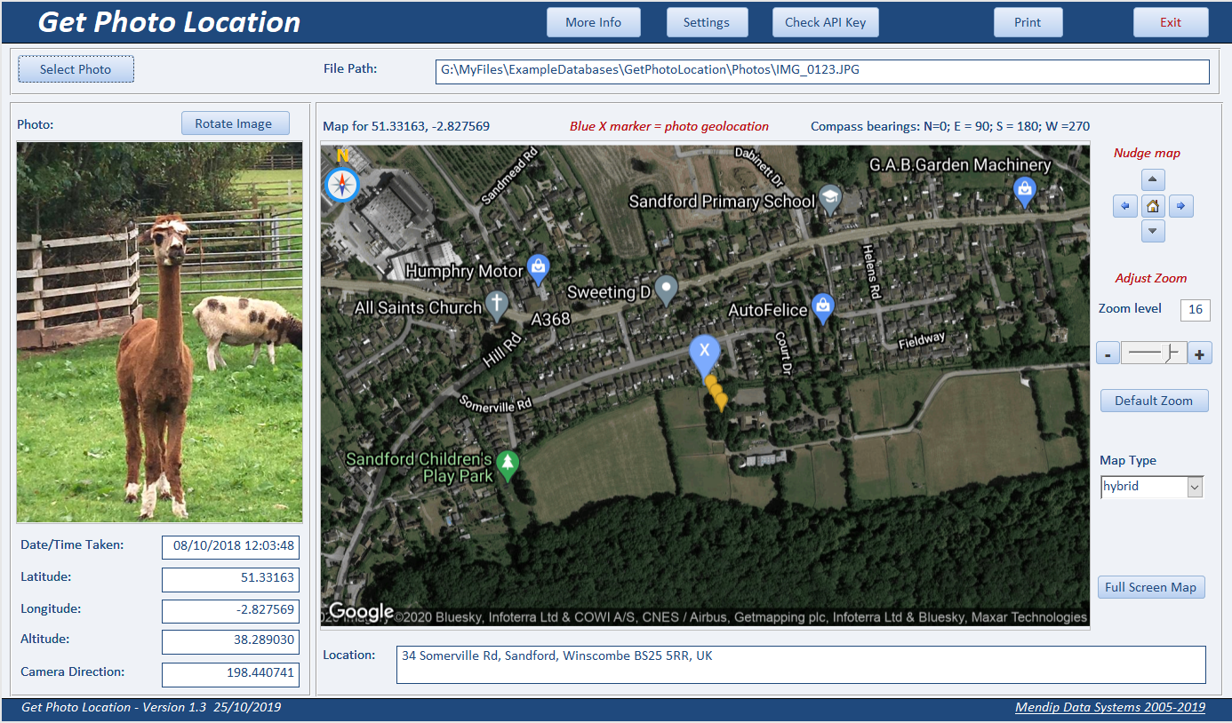
The app works by extracting the geolocation info which may be saved as part of the EXIF data stored with the photo.
The code used to do this was written by Wayne Phillips from EverythingAccess.com
See his article:
Extracting GPS Data From JPEG Files
The data extracted includes latitude, longitude & altitude together with the date/time taken.
A static Google map is then loaded centred on the saved location data.
Reverse geolocation is then used to display the closest address to the saved geolocation.

NOTE:
1. This only works for JPEG/JPG files (standard filetype for digital photos).
2. In addition, Location Services must be enabled on your phone / camera
3. Many older cameras/phones may not include this information.
A message is displayed to indicate when no geolocation data is available

Other features:
a) The photo may be rotated clockwise in intervals of 90 degrees if it isn’t properly displayed.
b) You can choose from the following map types: roadmap, terrain, satellite, hybrid
The map may be zoomed in/out or nudged up/down/left/right.
NOTE: Each change requires a new map to be downloaded but this is almost instantaneous
c) A full screen ‘dynamic’ map can also be used as an alternative
Using this app requires an Internet connection and a ‘free’ Google Maps API key
When the app is first opened, you will be prompted to enter an API key.

Follow the instructions on the form to obtain a Google Maps API key then enter it on the form.
You will need to provide billing details when you obtain your API key
However, downloading maps is free for small/medium use (currently 100,000 free requests per month) though charges can be significant for large scale use (currently $2 per extra 1000 requests per month).
I've also included 6 sample photos so you can test how the application works.
5 of the photos include geolocation data
Click to download:
Get Photo Location v1.2
(zipped - approx 1.8 MB)
Sample Photos (zipped - approx 0.8 MB)
Feedback
Please use the contact form below to let me know whether you found this article interesting/useful or if you have any questions/comments.
Please also consider making a donation towards the costs of maintaining this website. Thank you
Colin Riddington Mendip Data Systems Last Updated 25 Oct 2019
Return to Example Databases Page
Return to Top