
First Published 6 Dec 2022 Last Updated 7 Dec 2022 Difficulty level : Moderate
Section Links (this page):
Example App
VBA Code
Download
Related items/apps
Related articles/code
Useful links
Summary
Feedback
This is the third in a series of articles about annotating downloaded maps in Access
The first part of this article demonstrated several of the different ways that online maps can be modified by adding additional layers.
The second part discussed how the large amounts of data used with complex maps is managed using a combination of encoding and sampling.
This third article will be used to put all this information together including how the URLs are built up in code.
Explanations will be done with reference to an example app supplied with all code.
1. Example app Return To Top
The example app includes all the features described in this series of articles and is supplied with all required data for a range of 15 UK postcodes
You will need a free Google Maps API key in order to use the app
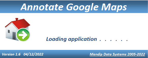
Splash form
The application opens to a small splash form which automatically closes after a couple of seconds
API form
The first time you use the application, the API Info form will appear next:
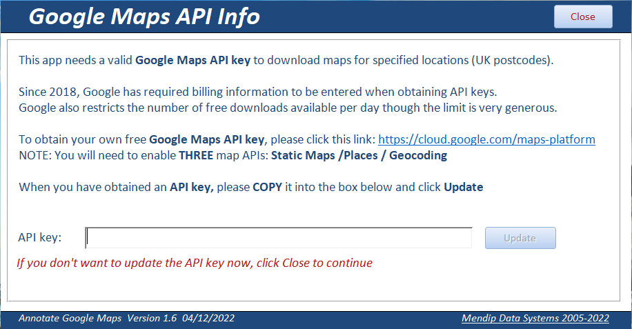
If you already have a Google Maps API key for the 3 specified APIs, Static Maps, Places & Geocoding, enter it now
Otherwise go to the Google Map Platform webpage, obtain an API key, copy and paste it into the form then click Update
NOTE: A valid Google Maps API key has 39 characters starting with AIzaSy
Now close the form. The Main form opens.
Main form
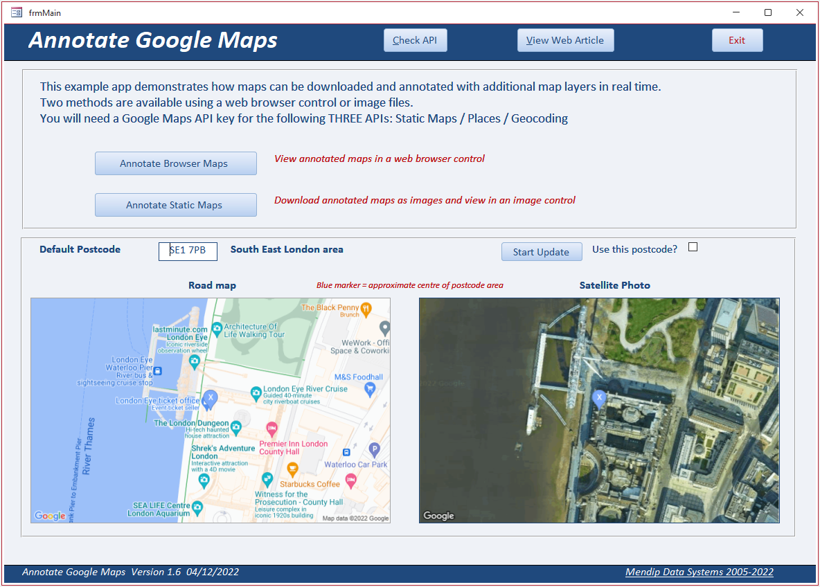
If you have previously entered a valid API key, the app will open this form directly from the splash form
The main form opens with two downloaded maps (roadmap/satellite) for the default postcode SE1 7PB.
This is an area of Central London which includes the London Eye tourist attraction
Click the Start Update button to cycle through each of the 15 postocdes in a random order using a timer event.
Every 5 seconds two new maps will be downloaded for the new postcode
OPTIONAL: If you want to use the currently selected postcode to create your own maps, click Pause Update and then check Use This Postcode
Click one of the map buttons: Annotate Browser Maps or Annotate Static Maps
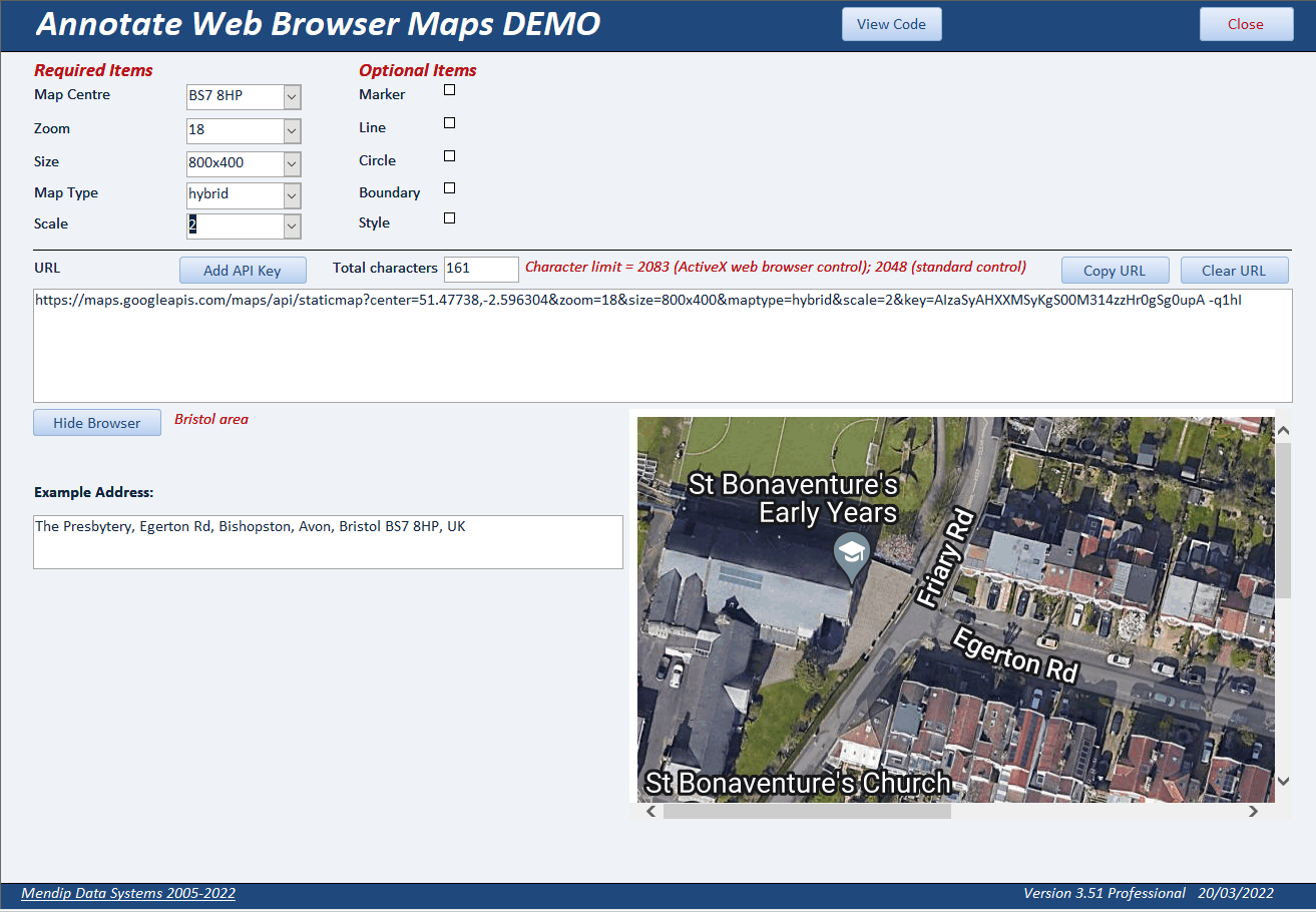
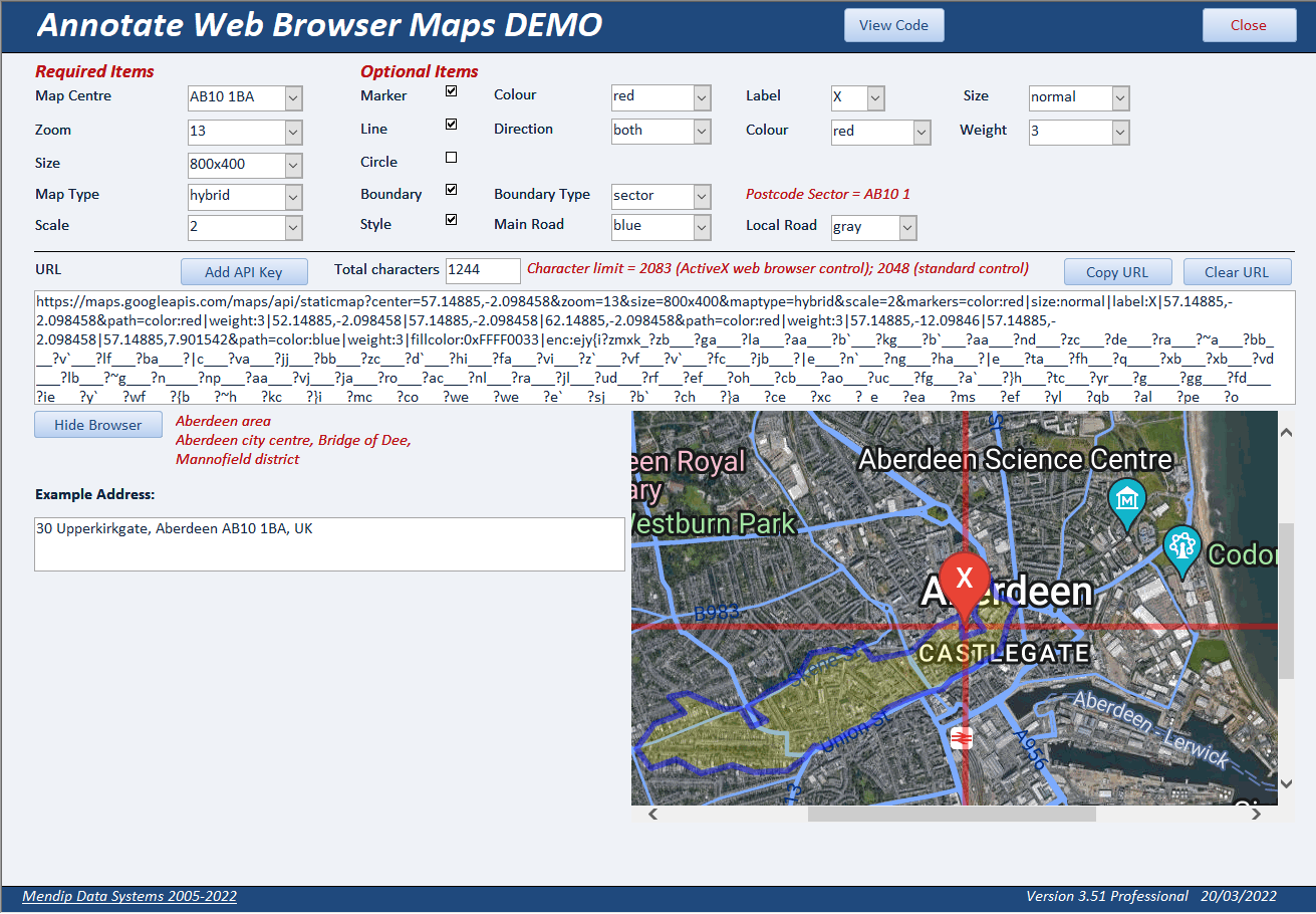
Web Browser form
Select from the options to build a map. As you do so, the information is updated in the URL textbox
The total number of characters is displayed for information.
When you have completed all required items, click the Add API Key button
The Show Browser button is now enabled. Click to create a map in the browser control. This is done using the Google Static Maps API
An example address is also displayed for the selected postcode. This is generated using the Geocoding API (see later for more details)
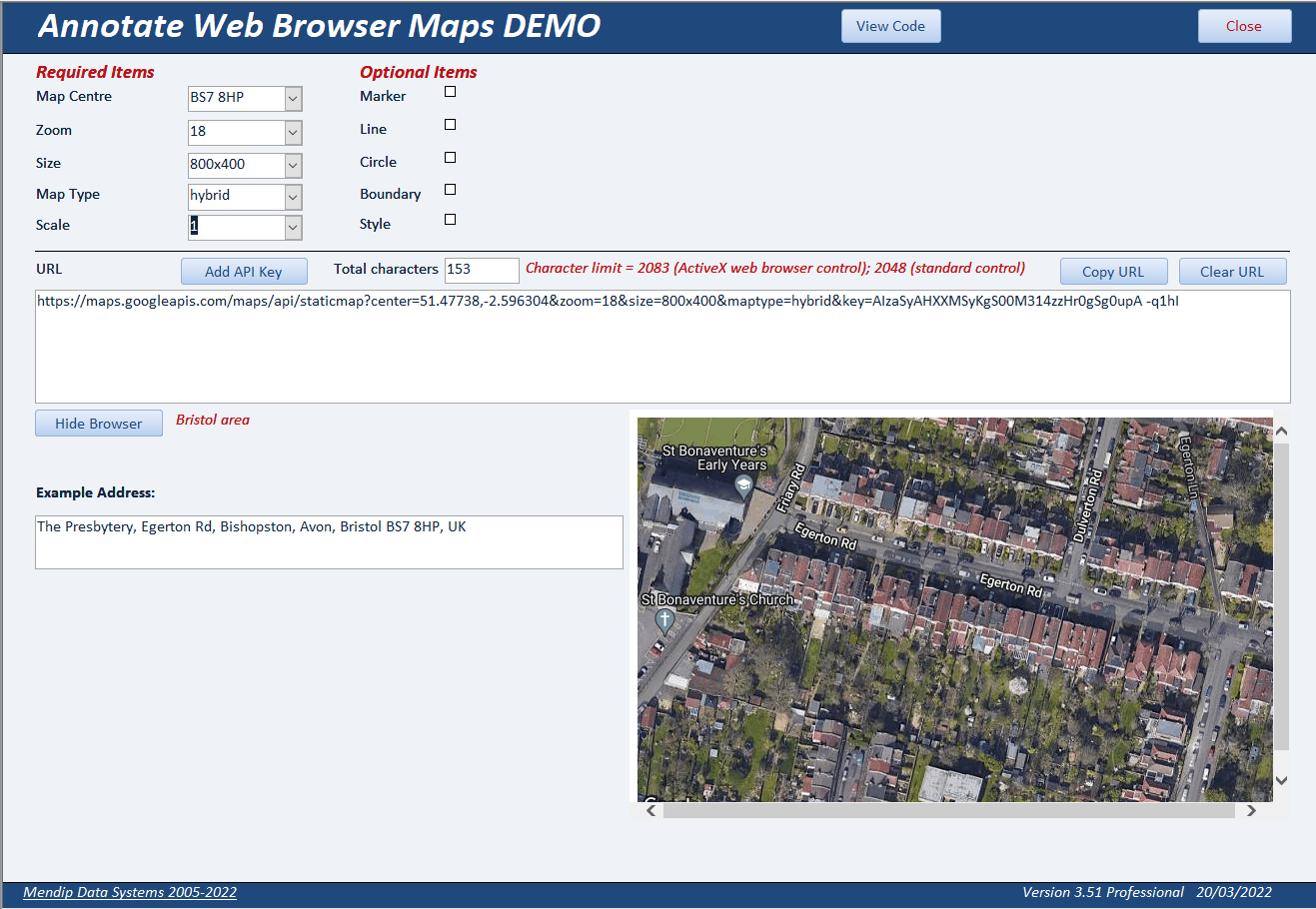
If you select Satellite or Hybrid as your map type, the Scale item appears with default value 1. Change to 2 for twice the resolution
NOTE:
The API key shown in the above screenshots is a dummy value used here for display purposes. It is NOT a valid API key and will not work!
You can also select one or more of the optional items to add additional layers to your map
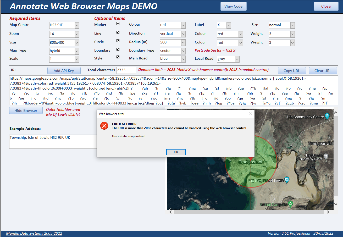
However, if you exceed the character limit (2083) for the browser control, this message wil be displayed
Downloaded Map Form
This is very similar to the web browser form but with additional options.
As before, select from the options to build a map. As you do so, the information is updated in the URL textbox
The total number of characters is displayed.
When you have completed all required items, click the Add API Key button then click Generate Map
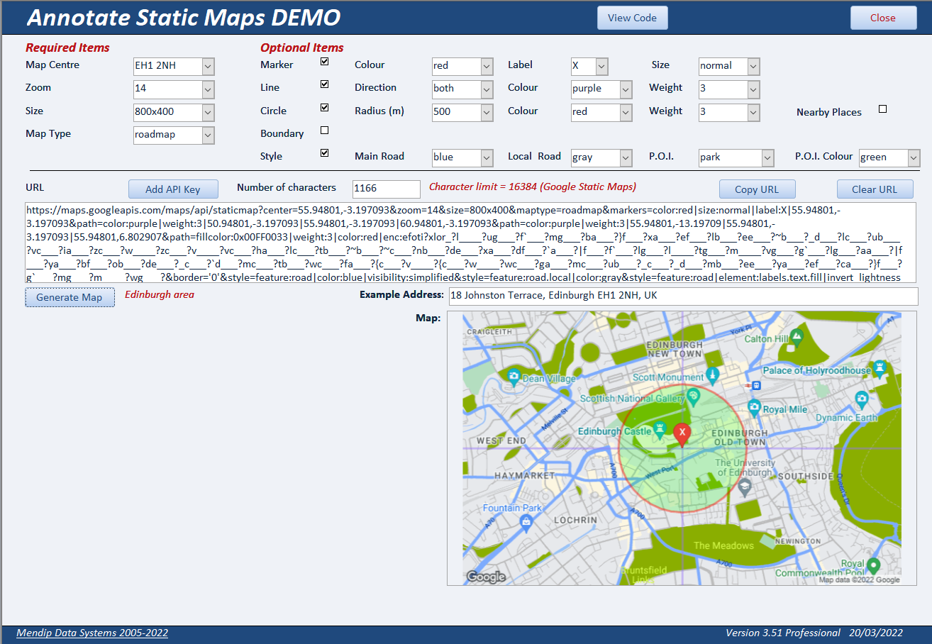
The map is saved with the file name map.png in the same folder as the example app
Each time a new map is created, this file is updated automatically
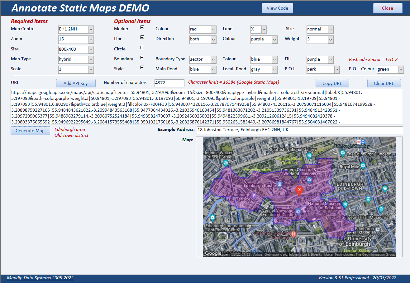
You can create more complex map layers without issues as the number of characters in the URL is no longer subject to the IE browser control limit.
The map shown below has a URL of almost 15500 characters
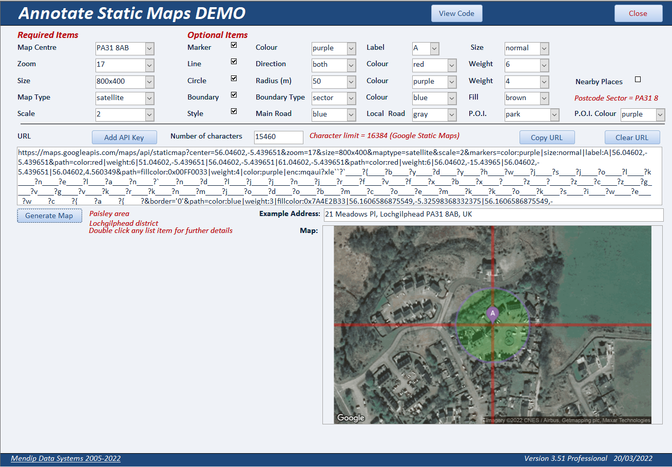
However it is still limited by the Google Maps URL limit which is currently 16384 (16K) characters
Due to the use of data encoding and data sampling, it is unlikely you will be able to build a URL which exceeds this limit
Nearby Places
Using the Static Maps form, complete all required items then tick the Circle checkbox and choose from the circle options. Next tick the Nearby Places checkbox.
The map type will change to roadmap and several other options will be automatically over-ridden for this purpose.
A circle will be drawn with the specified radius and up to 20 nearby places of interest will be displayed with a yellow marker within the circle.
The places will also be displayed in a listbox in alphabetical order
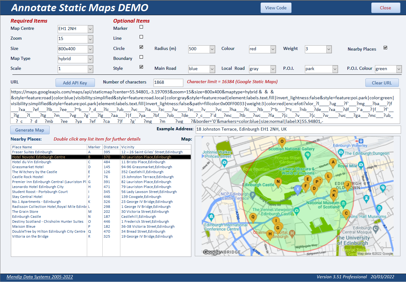
The list of places is generated using the Google Places API.
It is downloaded as a JSON file, analysed by the example app and the places data is stored (temporarily) in the table tblNearbyPlaces
In this example app, the places can be any type of location designated as a place of interest
However Google designates almost 100 different place types such as bank, restaurant, government building etc.
In my commercial app, UK Postal Address Finder, you can restrict the list to a specified place type only.
For example, this shows all the restaurants within 150 metres of the London Eye (postcode SE1 7PB)
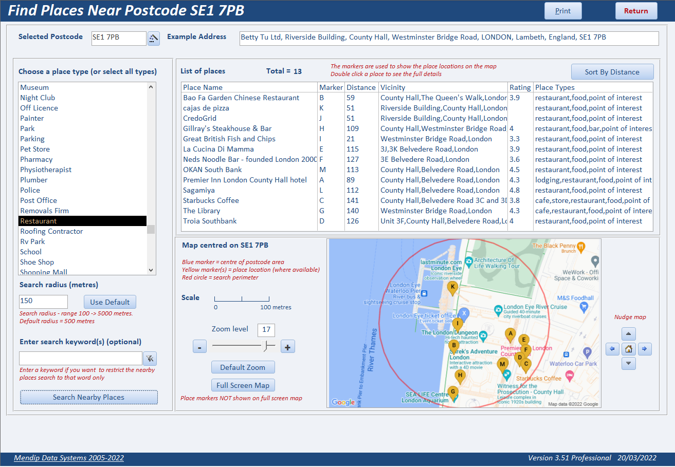
Double click on any item in the list to open the place detail form. This provides detailed information about the selected location including:
• address, phone and website URL
• photographs
• customer reviews
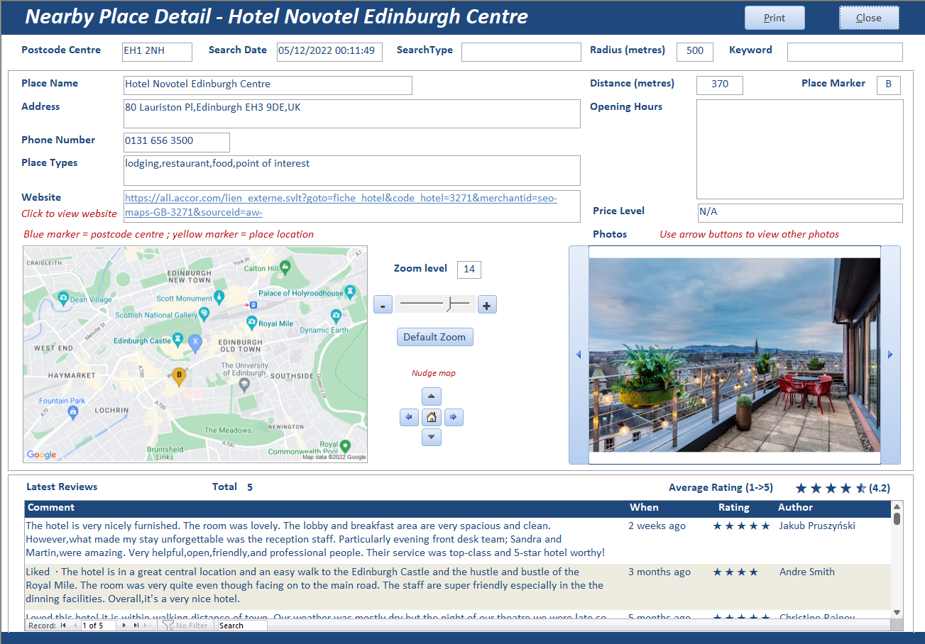
In addition, the map can be zoomed in/out and nudged left/right/up/down
A new map is generated after each change made
2. VBA Code Return To Top
Much of the code used in this example app has already been described in these related articles:
a) The first part of this series of articles: Annotate Google Maps - Part 1
b) Fix Google maps display issues in Access web browser control
c) Encoded Map Path Co-ordinates
d) Missing Trigonometric Functions
The following code is also used throughout the application
e) Get Address using Geocoding
This retrieves a typical address for the selected postcode location using the Geocoding API
Private Function GetAddress()
'---------------------------------------------------------------------------------------
' Function : GetAddress
' DateTime : 12/10/2018
' Author : Colin Riddington
' Company : Mendip Data Systems
' Purpose : Uses reverse geocoding to get address from postcode
' Credits : https//isladogs.co.uk
' Updated : Nov 2021
'---------------------------------------------------------------------------------------
On Error GoTo Err_Handler
Dim strAddress As String
sngLat = Nz(DLookup("Latitude", "Postcodes", "Postcode='" & Me.cboLocation & "'"), 100)
sngLong = Nz(DLookup("Longitude", "Postcodes", "Postcode='" & Me.cboLocation & "'"), 100)
'build url
strURL = GetGoogleGeocodingBase() & "?latlng=" & sngLat & "," & sngLong & " &key=" & GetGoogleMapsAPIKey()
strPath = Application.CurrentProject.Path & "\JSON\GeolocationAddress.json"
GetJSON:
'setup the request and authorization
Set http = New MSXML2.XMLHTTP60
http.Open "GET", strURL, False
http.Send ""
'save to file
Set stm = CreateObject("ADODB.Stream")
stm.type = 2 ' acTypeText
stm.Open
stm.WriteText http.responseText
stm.SaveToFile strPath, 2 'adSaveCreateOverWrite
ReadJSON:
' Read .json file
Set JsonTS = fso.OpenTextFile(strPath, ForReading, False, -1)
strJSON = JsonTS.ReadAll
' Debug.Print strJSON
JsonTS.Close
'get first formatted address location from JSON file
strAddress = Mid(strJSON, InStr(strJSON, "formatted_address") + 22, 100)
' Debug.Print strAddress
If strAddress Like "*REQUEST_DENIED*" Then
FormattedMsgBox "There is a problem with your API key" & _
"@Please check your API key is correct and try again @", vbCritical, "API key is NOT valid"
DoCmd.Close acForm, Me.Name
DoCmd.OpenForm "frmAPI"
Else
strAddress = Left(strAddress, InStr(strAddress, """") - 1)
'Debug.Print strAddress
Me.txtAddress = strAddress
End If
Exit_Handler:
Exit Function
Err_Handler:
FormattedMsgBox "Error " & Err.Number & " in GetAddress procedure : " & _
"@" & Err.Description & " @", vbCritical, "Program error"
Resume Exit_Handler
End Function
The JSON output is saved in the file GeolocationAddress.json. It is then analysed and the first recognised address is shown on the map forms
f) Draw circles around a specified location
This uses 2 procedures:
• GMapCircle - creates the location data points for the circle
• PopulateMapCircleData - saves the data to a temporary table
Function GMapCircle(Lat, Lng, Rad, Detail)
'---------------------------------------------------------------------------------------
' Function : GMapCircle
' DateTime : 12/10/2018
' Author : Colin Riddington
' Company : Mendip Data Systems
' Purpose : Used to create location data points to draw a circle
' Credits : https//isladogs.co.uk
' : modified version of code written in PHP by Oliver Beattie / Josh McDonald
' : http://jomacinc.com/map-radius/
' Updated : Nov 2021
'---------------------------------------------------------
'Set detail = 10 to get records every 10 degrees around circle
'Detail = 10
Dim R As Long, D As Single
Dim brng As Double
Dim Points() As Variant
Dim arrValues As Variant
Dim pLat As Double, pLng As Double
R = 6371000 'earth radius in km
'Rad = radius of circle (metres)
Lat = (Lat * Pi) / 180
Lng = (Lng * Pi) / 180
D = Rad / R 'scaling factor
I = 0
'populate table with circle points
Set RST = CurrentDb.OpenRecordset("tblMapCircle", dbOpenDynaset)
With RST
For I = 0 To 360 Step Detail
brng = I * Pi / 180
pLat = ASin((Sin(Lat) * Cos(D)) + (Cos(Lat) * Sin(D) * Cos(brng)))
pLng = ((Lng + Atn2(Sin(brng) * Sin(D) * Cos(Lat), Cos(D) - Sin(Lat) * Sin(pLat))) * 180) / Pi
pLat = (pLat * 180) / Pi
'Debug.Print i, pLat, pLng
.AddNew
!Bearing = I
!Latitude = pLat
!Longitude = pLng
.Update
Next
.Close
End With
Set RST = Nothing
End Function
'===============================================
Private Sub PopulateMapCircleData()
'---------------------------------------------------------------------------------------
' Procedure : PopulateMapCircleData
' DateTime : 12/10/2018
' Author : Colin Riddington
' Company : Mendip Data Systems
' Purpose : Used to save circle location data points to a table
' Credits : https//isladogs.co.uk
' Updated : Nov 2021
'---------------------------------------------------------
On Error GoTo Err_Handler
Dim intDetail As Integer
intDetail = 10 'bearing every 10 degrees
'get lat / long data for circle points & add to tblMapCircle
GMapCircle sngLat, sngLong, lngRad, intDetail
'multiply values by 10000
CurrentDb.Execute "UPDATE tblMapCircle SET tblMapCircle.LatE5 = 100000*[Latitude], tblMapCircle.LongE5 = 100000*[Longitude];"
'get previous values and append to tblMapCirclePrevLatLong
CurrentDb.Execute "qryAppendMapCirclePrevLatLong"
'update first record where bearing = 0
CurrentDb.Execute "UPDATE tblMapCirclePrevLatLong" & _
" SET tblMapCirclePrevLatLong.PrevLatE5 = 0, tblMapCirclePrevLatLong.PrevLongE5 = 0" & _
" WHERE (((tblMapCirclePrevLatLong.Bearing)=0));"
'populate tblMapCircle from tblMapCirclePrevLatLong
CurrentDb.Execute "UPDATE DISTINCTROW tblMapCircle INNER JOIN tblMapCirclePrevLatLong" & _
" ON tblMapCircle.Bearing = tblMapCirclePrevLatLong.Bearing" & _
" SET tblMapCircle.PrevLatE5 = [tblMapCirclePrevLatLong].[PrevLatE5]," & _
" tblMapCircle.PrevLongE5 = [tblMapCirclePrevLatLong].[PrevLongE5];"
'populate change in latitude & longitude between records
CurrentDb.Execute "UPDATE tblMapCircle" & _
" SET tblMapCircle.LatChange = [LatE5]-[PrevLatE5], tblMapCircle.LongChange = [LongE5]-[PrevLongE5];"
'encode each record using EncGeoCode function
CurrentDb.Execute "UPDATE tblMapCircle" & _
" SET tblMapCircle.EncLat = EncGeoCode([LatChange]), tblMapCircle.EncLong = EncGeoCode([LongChange])," & _
" tblMapCircle.EncPoint = EncGeoCode([LatChange]) & EncGeoCode([LongChange]);"
Exit_Handler:
Exit Sub
Err_Handler:
FormattedMsgBox "Error " & Err.Number & " in PopulateMapCircleData procedure : " & _
"@" & Err.Description & " @", vbCritical, "Program error"
Resume Exit_Handler
End Sub
g) NearbyPlacesImport
This is used to import a list of places of interest within a specified radius of the selected location
Private Sub NearbyPlacesImport()
'---------------------------------------------------------------------------------------
' Procedure : NearbyPlacesImport
' DateTime : 22/10/2018
' Author : Colin Riddington
' Company : Mendip Data Systems
' Purpose : Used to import JSON data for places of interest within a specified radius of the selected location
' Credits : https//isladogs.co.uk
' Updated : Nov 2021
'---------------------------------------------------------
On Error GoTo Err_Handler
If GetInternetConnectedState = False Then
If blnSilent = False Then
blnSilent = True
FormattedMsgBox "You are not currently connected to the Internet " & _
"@Nearby places & location map data cannot be downloaded " & vbCrLf & vbCrLf & _
"Please try again later @", vbCritical, "No Internet connection"
End If
Exit Sub
Else
blnSilent = False
End If
Dim Results As Variant, geometry As Variant, location As Variant, types As Variant
Dim photos As Variant, arrValues As Variant, rst As DAO.Recordset
'Google Places API
lngRadius = Nz(Me.cboRad, 500) 'default = 500 metres
sngLat = Nz(DLookup("Latitude", "Postcodes", "Postcode='" & Me.cboLocation & "'"), 100)
sngLong = Nz(DLookup("Longitude", "Postcodes", "Postcode='" & Me.cboLocation & "'"), 100)
'check for required information
If sngLat = 100 Or sngLong = 100 Then
FormattedMsgBox "The nearby places search cannot be done " & _
"@Required geolocation information is missing @", vbCritical, "Cannot run nearby places search"
Exit Sub
End If
If GetGoogleMapsAPIKey = "" Then
FormattedMsgBox "The nearby places search cannot be done " & _
"@Google Places API key information is missing @", vbCritical, "Cannot run nearby places search"
Exit Sub
End If
strPlaces = GetGooglePlacesBase & "?location=" & sngLat & "," & sngLong & "" & _
"&radius=" & lngRadius & "&key=" & GetGoogleMapsAPIKey
strPath = Application.CurrentProject.Path & "\JSON\NearbyPlacesImport.json"
' Debug.Print strPlaces
GetJSON:
'setup the request and authorization
Set http = New MSXML2.XMLHTTP60
http.Open "GET", strPlaces, False
http.Send ""
'save to file
Set stm = CreateObject("ADODB.Stream")
stm.type = 2 ' acTypeText
stm.Open
stm.WriteText http.responseText
stm.SaveToFile strPath, 2 'adSaveCreateOverWrite
'End of Online section
'====================================
ReadJSON:
' Read .json file
Set JsonTS = fso.OpenTextFile(strPath, ForReading, False, -1)
strJSON = JsonTS.ReadAll
'Debug.Print strJSON
JsonTS.Close
'check for empty search results or other errors
If Not strJSON Like "*" & """status"" : ""OK""" & "*" Then
If strJSON Like "*" & "ZERO_RESULTS" & "*" Then
FormattedMsgBox "There are no results for this nearby places search " & _
"@Postcode = " & String(2, " ") & "'" & strPostcode & "'" & vbCrLf & _
"Radius = " & String(7, " ") & "'" & lngRadius & "'" & vbCrLf & _
"Type = " & String(10, " ") & "'" & strSearchType & "'" & vbCrLf & _
"Keyword = " & String(4, " ") & "'" & strKeyword & "'" & vbCrLf & vbCrLf & _
"Please try again with different search criteria @", vbExclamation, "No matching search results"
Me.Requery
DoEvents
Exit Sub
Else
FormattedMsgBox "Unknown error for this nearby places search " & _
"@Postcode = " & String(2, " ") & "'" & strPostcode & "'" & vbCrLf & _
"Radius = " & String(7, " ") & "'" & lngRadius & "'" & vbCrLf & _
"Type = " & String(10, " ") & "'" & strSearchType & "'" & vbCrLf & _
"Keyword = " & String(4, " ") & "'" & strKeyword & "'" & vbCrLf & vbCrLf & _
"Please try again with different search criteria @", vbExclamation, "No matching search results"
Exit Sub
End If
End If
'============================================
RemoveUnwantedSpaces:
'remove unwanted spaces around brackets
' Debug.Print "LenStart " & Len(strJSON)
Dim LS As Long, LE As Long
LS = Len(strJSON)
'strJSON = Replace(Replace(strJSON, "[ {", "[{"), "} ]", "}]")
strJSON = Replace(Replace(strJSON, "[ ", "["), " ]", "]")
strJSON = Replace(Replace(strJSON, "{ ", "{"), " }", "}")
strJSON = Replace(Replace(strJSON, """ ", """"), " """, """")
strJSON = Replace(Replace(strJSON, ", ", ","), " ,", ",")
strJSON = Replace(strJSON, ": ", ": ")
LE = Len(strJSON)
If LE < LS Then GoTo RemoveUnwantedSpaces
' Debug.Print "LenEnd " & Len(strJSON)
'now that unwanted spaces have been removed, line feeds can also be removed
strJSON = Replace(Replace(strJSON, vbLf, ""), vbCr, "")
'add missing array brackets
strJSON = Replace(strJSON, """geometry"": {", """geometry"": [{")
strJSON = Replace(strJSON, ",""icon""", "],""icon""")
strJSON = Replace(strJSON, """location"": {", """location"": [{")
strJSON = Replace(strJSON, "},""viewport""", "}],""viewport""")
' Debug.Print "LenFinal " & Len(strJSON)
strJSON = Trim(strJSON)
'Debug.Print strJSON
'============================================
'write to table tblNearbyPlaces
Set rst = CurrentDb.OpenRecordset("tblNearbyPlaces", dbOpenDynaset, dbSeeChanges)
Set JSON = modJsonConverter.ParseJSON(strJSON)
'Debug.Print JSON
icount = 65 'ASCII code for capital A
strPostcode = Replace(Me.cboLocation, " ", "+")
With rst
For Each Results In JSON("results")
For Each geometry In Results("geometry")
For Each location In geometry("location")
For Each types In Results("types")
For Each photos In Results("photos")
.AddNew
'ID = autonumber PK field
!Postcode = strPostcode
!SearchDate = Now()
!Radius = lngRadius
!SearchType = strSearchType
!Keyword = strKeyword
!PlaceName = Results("name")
!PlaceMarker = Chr(icount) 'assign letter for map marker
!PlaceID = Results("place_id")
!Longitude = location("lng")
!Latitude = location("lat")
!Vicinity = Results("vicinity")
!Rating = Results("rating")
!PhotoReference = photos("photo_reference")
'get distance from postcode mean in metres
!Distance = GetDistanceMetres(sngLat, sngLong, !Latitude, !Longitude)
If !Distance > !Radius Then GoTo NextItem
'types - subarray of values
arrValues = Split(types, ",")
For zCount = 0 To UBound(arrValues)
' Debug.Print zCount; UBound(arrValues)
If strSelection = "" Then
strSelection = arrValues(zCount)
Else
strSelection = strSelection & "," & arrValues(zCount)
End If
strSelection = Replace(strSelection, "_", " ")
strSelection = Replace(strSelection, "establishment", "")
'strSelection = Replace(strSelection, "point of interest", "")
strSelection = Replace(strSelection, "locality", "")
strSelection = Replace(strSelection, "political", "")
strSelection = Replace(strSelection, ",,", ",")
'remove trailing comma
If Right(strSelection, 1) = "," Then strSelection = Left(strSelection, Len(strSelection) - 1)
If strSelection = "" Then GoTo NextItem
Next
Next
Next
.Update
Next
Next
strSelection = ""
icount = icount + 1
NextItem:
Next
.Close
End With
' Debug.Print strSelection
Set rst = Nothing
UpdateURL
Exit_Handler:
Exit Sub
Err_Handler:
If Err = 3420 Or Err = 13 Or Err = 92 Or Err = 94 Then Resume Next
MsgBox "Error " & Err.Number & " in NearbyPlacesImport procedure : " & vbCrLf & _
nbsp; Err.Description, vbCritical, "Cannot create table"
End If
Resume Exit_Handler
End Sub
The JSON output is saved in the file NearbyPlacesImport.json. It is then analysed and the data is stored in the table tblNearbyPlaces.
The places data is also displayed in a listbox
Similar code is used in the NearbyPlaceDetailJSONImport procedure with the additional data saved in the file NearbyPlaceDetailsImport.json.
It is then analysed and the data is stored in the tables tblNearbyPlacePhotos and tblNearbyPlaceReviews.
h) UpdateURL
After each selection is made on one of the map forms, an update procedure ensures the URL includes all the currently selected features.
For example, this code is used to update the marker type required:
Private Sub UpdateMarker()
'---------------------------------------------------------------------------------------
' Procedure : UpdateMarker
' DateTime : 24/09/2018
' Author : Colin Riddington
' Company : Mendip Data Systems
' Purpose : Used to update the marker type in a map layer
' Credits : https//isladogs.co.uk
' Updated : Nov 2021
'---------------------------------------------------------
If chkMarker = True Then
sngLat = DLookup("Latitude", "Postcodes", "Postcode='" & Me.cboLocation & "'")
sngLong = DLookup("Longitude", "Postcodes", "Postcode='" & Me.cboLocation & "'")
strMarker = "&markers=color:" & Me.cboMarkerColor & "|size:" & Me.cboMarkerSize & "|label:" & Me.cboLabel & "|" & sngLat & "," & sngLong
Else
strMarker = ""
End If
' Debug.Print strMarker
UpdateURL 'update the URL with strMarker value
End Sub
Similar (but much more complex) code runs after other option changes: UpdateBoundary, UpdateCircle, UpdateLine and UpdateStyle
At the end of each of these procedures , the UpdateURL procedure is then run.
This combines the data from all selections together wth the API key to create the map URL.
Private Sub UpdateURL()
'---------------------------------------------------------------------------------------
' Procedure : UpdateURL
' DateTime : 24/09/2018
' Author : Colin Riddington
' Company : Mendip Data Systems
' Purpose : Combines the data from all map selections together wth the API key to create the map URL
' Credits : https//isladogs.co.uk
' Updated : Nov 2021
'---------------------------------------------------------
On Error GoTo Err_Handler
Dim strBase As String
If Me.chkPlaces = True Then
strBase = GetGooglePlacesBase
Else
strBase = GetGoogleStaticMapsBase
End If
'combine the Google base string with the saved values from the location, zoom, map size, map type & scale values
... and the marker, line, circle, boundary and style options (if used)
Me.txtURL = strBase & "?" & strLoc & strZoom & strSize & strType & strScale & strMarker & strLine & strCircle & strBoundary & strStyle
If blnAPIKey = True Then
...add the API key
Me.txtURL = Me.txtURL & "&key=" & GetGoogleMapsAPIKey()
End If
Me.txtURL.Requery
show the number of characters in the URL
Me.txtChar = Len(Me.txtURL)
If Me.txtChar > 0 Then
cmdClear.enabled = True
cmdCopy.enabled = True
End If
If strLoc <> "" And strZoom <> "" And strSize <> "" And strType <> "" Then
'enable API Key button & optional items
cmdKey.enabled = True
Me.chkMarker.enabled = True
Me.chkLine.enabled = True
Me.chkCircle.enabled = True
Me.chkBoundary.enabled = True
Me.chkStyle.enabled = True
End If
Exit_Handler:
Exit Sub
Err_Handler:
FormattedMsgBox "Error " & Err.Number & " in UpdateURL procedure : " & _
"@" & Err.Description & " @", vbCritical, "Program error"
Resume Exit_Handler
End Sub
i) Create map images
When the GenerateMap button is clicked, the GetMapImage procedure is run
Private Sub GetMapImage()
'---------------------------------------------------------------------------------------
' Procedure : GetMapImage
' DateTime : 24/09/2018
' Author : Colin Riddington
' Company : Mendip Data Systems
' Purpose : Used to download a map image based on a specified location with selected properties and additional map layer criteria
' Credits : https//isladogs.co.uk
' Updated : Nov 2021
'---------------------------------------------------------
On Error GoTo Err_Handler
If GetInternetConnectedState = False Then
If blnSilent = False Then
blnSilent = True
FormattedMsgBox "You are not currently connected to the Internet " & _
"@The location map cannot be updated @", vbCritical, "No Internet connection"
End If
ShowControls False, "M", "X" 'hide map controls
ShowControls True, "C" 'show no internet message
Exit Sub
Else
blnSilent = False
ShowControls False, "C" 'hide no internet message
End If
Application.Echo False
'set map path
strFilePath = CurrentProject.Path & "\" & "map.png"
'get URL for map including API key
strURL = Me.txtURL
' Debug.Print strURL
'Download map
DownloadFilefromWeb strURL, strFilePath
DoEvents
If Len(strFilePath) <> 0 Then
Me.Image0.Picture = strFilePath
Me.Image0.Requery
End If
Application.Echo True
ShowControls True, "M" 'show map controls
Exit_Handler:
Exit Sub
Err_Handler:
FormattedMsgBox "Error " & Err.Number & " in GetMapImage procedure : " & _
"@" & Err.Description & " @", vbCritical, "Program error"
Resume Exit_Handler
End Sub
Similar code is used in the GetPlacesMapImage procedure
3. Download Return To Top
The zip file contains the example app together with 3 JSON files in the JSON folder. Map image files are created as required
Click to download: View AnnotateGoogleMaps_v1.7 Approx 4 MB (zipped)
The example app is supplied as an ACCDB file with all code.
It should work in all Access versions from 2010 onwards, both 32-bit and 64-bit
NOTE:
You are permitted to use the code in your own applications providing all copyright information is included in full and without any changes made.
However, you must ask for permission from Mendip Data Systems to use any of this code in commercial applications.
4. Other related items / example apps
Return To Top
The following apps use various geolocation features to generate maps. All are available elsewhere on this website:
a) Get Geolocation from Photos (FREE)
b) Get Current Geolocation (FREE)
c) UK Postcode Address Lookup (FREE)
d) UK Postal Address Finder (PAID)
5. Related articles / code
Return To Top
The following articles also include code used in various parts of this application
a) Encoded Map Path Co-ordinates
b) Missing Trigonometric Functions
c) Fix Google maps display issues in Access web browser control
6. Useful links
Return To Top
The following links will also help you get started on creating your own maps in Access:
a) Google Static Maps API Developers Guides
https://developers.google.com/maps/documentation/maps-static/start
https://developers.google.com/maps/documentation/maps-static/styling
b) Google Nearby Places API Developers Guide
https://developers.google.com/maps/documentation/places/web-service/search-nearby
c) IE browser URL character limit
Maximum URL length is 2,083 characters in Internet Explorer (microsoft.com)
What is the maximum length of a URL in different browsers? - Stack Overflow
How long of a URL can Internet Explorer 9 take? - Stack Overflow
7. Summary
Return To Top
The above article was the third in a series of articles for this website.
The features of the example appwere explained together with how the URLs can be built up in code from the various options selected.
It was also used to explain several of the procedures involved.
8. Feedback
Return To Top
Please use the contact form below to let me know whether you found this article useful or if you have any questions.
Please also consider making a donation towards the costs of maintaining this website. Thank you
You may also be interested in my commercial app UK Postal Address Finder which includes all the above features as a small part of a much larger set of features.
Colin Riddington Mendip Data Systems Last Updated 7 Dec 2022
Return to Access Articles
Page 3 of 3
1
2
3
Return To Top
|
|
|